
Antique Baths
Thermal Healing Bath in Bansko near Strumica
At the north foot of Mt. Belasica, approximately 12 km from the city of Strumica, a powerful spring of hot water (72º C) gushes forth. The spring is in the village of Bansko; the etymology of the name of the village derives precisely from the presence of this spring and the baths that were once built there.
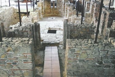
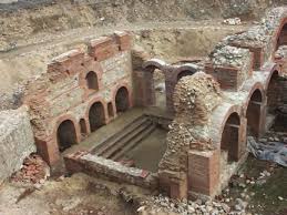
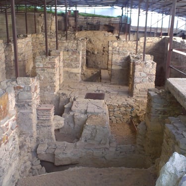
Archaeological excavations began at the spring of Parilo on this site thirty years ago and by now, a large part of a Roman bath built in the 2nd century has been discovered. The structures survive almost in their entirety; they cover more than 1,500 m2, the size making these thermae one of the largest in the Balkan region. Most of the 11 chambers have different functions and are built mostly of bricks combined with stone and mortar, which results in the achievement of a superior and harmonious polychrome effect. The heating in the interior was designed and executed by means of a special system which used hot water to heat the floors and the walls. The bath is designed as the majority of Roman structures and was built in the spirit of the needs of the Roman health cult.
There was also an apodyterium (changing room) where the visitors undressed and left their garments before going into the bath. In the space known as the dypterium, both the ailing and the regular visitors oiled themselves. The chamber known as the tepidarium was between the hot bath (caldarium) and the cold bath (frigidarium).
The main area of the thermae had a pool and tubs which were ca. 1.5 m deep, with steps for entering the pool. The light that entered through the windows made the interior private and intimate, and rose oil and amber gave the steam a distinctive, agreeable scent.
The current archaeological research has shown that it had existed even earlier as a sanatorium, a fact to which the newly excavated earlier structures bear witness. Built to meet the needs of the people in Antiquity, the baths were also a centre of social life. Around them, gymnasiums and libraries were built, and there were also temples dedicated to deities which were believed to ensure good health.
This bath with healing waters fell into neglect in the 6th century AD. However, the thermal springs remained attractive to the population from this region until the late Middle Ages, as the toponym Turkish Bath suggests; the second well-known toponym is Panagjur (Fair) which indicates that the Christian believers not only came to pray in the vicinity of these springs, but also entertained themselves and traded as well.
This Roman thermal bath could be fully reconstructed with only minor technical interventions, which would restore its former function and the purpose it once had, more than 1,500 years ago.
References:
J.Ananiev, “Arheolo{ko iskopuvawe na lokalitetot ‘ Turska bawa’- Pana|ur, selo Bansko kaj Strumica 1978-1981”, Zbornik na trudovi, Strumica 1989, 333-339.
S.Taseva, V. Sekulov, “Docnoanti~koto termalno le~ili{te vo s.Bansko kaj Strumica”, Kulturno nasledstvo, 28-29, Skopje 2004, 261-271.
S. Taseva, V.Sekulov, “The hypocaust in the sudatorium of the late Roman thermal spa in the village of Bansko by Strumica”. The lower Danube in Antiquity (6th century BC to 6th century AD), Sofia 2007, 235-246.
Bargala
Bargala
Late Antique and Early Byzantine City
Kiril Trajkovski
The Late Antique city of Bargala is situated 10 km southeast of the city of Štip, at the foot of Mt. Plačkovica. Its name as a toponym has a Thracian component and, taken as a whole, it means overflowing water. In the 7th and 6th centuries BC this area belonged to the territory settled by the Paeonian tribe of Derrones who were among the first tribes in the world that minted silver coins.
Astibos is the Antique name of the river Bregalnica in which, according to the Antique historiographer Polienus, the Paeonian kings took ritual baths at coronation.
The first site of the city of Bargala was 1 km south of the river, near the location known as Hamče, near the village of Karbinci. On this site, remains of walls, a xenodocheion (inn), a basilica and a huge stone dating from 371 with an inscription which refers to the building of the city gates of the city of Bargala in the Roman province Dacia Mediterranea.
By the 5th century AD, the city had already been firmly Christianized, and its Bishop Dardanius was a participant from Macedonia Prima; his name is recorded in the acts of the Ecumenical Council of Chalcedon in 451.
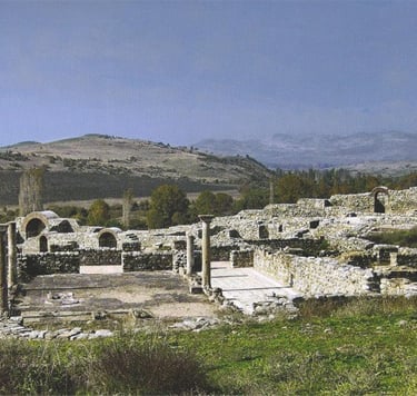
The instability in the Late Roman Empire in the 4th and 5th centuries caused by the barbarian onslaughts from the north forced the inhabitants of the city to withdraw 4 km towards the south, at the foot of Mt. Plačkovica and the site known as Kozji Grad, where they continued living their urban style of life. Here, the fortified Early Byzantine city of Bargala, covering an area of 4.7 hectares, additionally secured with 6 defensive towers, was built after the model of Late Roman castrums.
The city was accessed through the double (dipilon) main gate (porta principalis) which was exceptionally well guarded. It was built on the northwest rampart which was up to 12 m high; inside the city, there was a sewage system which supplied the more important buildings and fountains with water that was brought from the mountain.
At present, several public buildings have been discovered, as well as shops and workshops that served the citizens in the period between the 5th and the beginning of the 7th centuries. The most impressive structure is the three-nave episcopal basilica which was accessed by a steep and high stairway; the three entrances (tribelon) led to the lavishly decorated interior of this temple. The skill of the local stonemasons and mosaic artisans is evident, especially in the manufacture of the architectural elements, church mobiliary and floor mosaics panels.
The artistic style is characteristic of the Early Byzantine and Christian art of the 5th and 6th centuries in Macedonia. On one of the capitals, Hermias, Bishop of Bargala, carved a prayer for salvation; he was probably also the donor of the church. A baptisterium with a piscina in which Christians were baptized has been discovered next to the north wall o this building. A single-nave chapel was added next to the south wall of the basilica. The episcopal residence stood on the northwest side; it had a small thermal bath, next to which a larger one was built for a larger number of visitors. A series of chambers were built near the northwest and southeast ramparts, which are believed to have been used as workshops and shops, as well as dwelling places.
The citizens carried out their funeral and spiritual rites outside the city walls (extra muros); therefore, 85 m north of the main gate, a basilica was used in the period between the 4th and 6th centuries. The vaulted tomb discovered east of this sacral building was also part of the citizens’ spiritual life.
The section of the city that has been excavated (less than 1/10 of the actual size) yielded several hidden hoards of coins, luxurious objects and complete artisan tool kits. In the darkest historical period that lasted from the 7th to the end of the 9th centuries, small groups of people settled among the ruins of the city and the city ramparts. They led a rural life and their material culture is much less significant than that of their predecessors, the Rhomeioi.
In the 10th century, a rural settlement known as Kozjak was formed on the site near the Antique city of Bargala and the river Kozjačka; it survived until the 19th century. A small church dedicated to St. George, whose architectural and artistic achievements hold a significant place in Byzantine art was also built on this site.
References
I. VenedikovÝ , Bargala, RP INAM ¶. (n.s. N* 1), SofiÔ , 1948., 82-98.
C.Mango, B. Aleksova , Bargala: A Preliminary Report, DOP N* 25,1971, 265-(277)-281.
Z. Beldedovski , Bargala, Vodi£, [tip 2005.
Carevi Kuli
Carevi Kuli near Strumica, Kiril Trajkovski
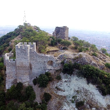
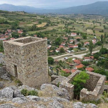
Carevi Kuli is the most impressive archaeological site in the city of Strumica, known as Tiberiopolis in the Middle Ages. It is a high hill that rises southwest of the mediaeval and present-day city. Today, under the city houses and yards in the central and old parts of the city remains of old houses, shops and churches from the period of Antiquity to the Ottoman period are regularly discovered. Due to their position, Carevi Kuli has a defensive role, while the earliest traces of life date from ca. 3,500 BC. In the Late Antique and Early Byzantine periods the hill was surrounded by ramparts and towers that guaranteed the safety of a selected part of the population.
In the 9th century, the city was conquered by the Bulgarians because of its favourable position in terms of its potential as a point of communication and its fame as a holy site: Strumica is the city of the Fifteen Martyrs of Tiberiopolis and as such, it was much desired by the first Bulgarian Christian ruler, Prince Boris Michael.
As a city and a fortress, Tiberiopolis and Carevi Kuli played an important role in the wars between Byzantium and the Macedonian Tsar Samuil until 1018.
After its conquest, the Byzantines reorganized its defense by constructing new ramparts and towers, thus dominating over the region and the city as long as until the 14th century. Carevi Kuli changed its structure depending on the changing warfare techniques and different military tactics. Today, the remains of the smaller and wider ramparts of the suburbium can still be seen, and part of the acropolis still stands on the highest point. Of he hill. A gate stands on the west side, supported by two towers. A deep trench was dug in front of the entrance, across which a drawbridge was lowered.
A polygonal tower that partly survives stands on the most dominating point of the acropolis, which was reserved for the city and military elite. East of the tower there is a large water cistern that was a necessity during the sieges.
The pottery, tools and coins that have been discovered reflect the mediaeval life in the fortress until the conquest of the Ottoman Turks. It happened in 1395, when Prince Constantine Dragaš, who ruled in this region, died as a Turkish vassal in the Battle of Rovine. During the Ottoman period, the life in Carevi Kuli was obliterated and its function ceased, while the city itself became the seat of the Ottoman kaaza (administrative region of the Ottoman empire).
References:
М. Јовановиќ, Две средновековни тврдини во источна Македонија, ЗШНМ, II, Штип 1961.
Ј. Анаnиев, Археолошка карта на Р. Македонија, II, Струмица – Цареви Кули, 414 – 415,Скопје 1996.
Grad
Grad near Delčevo, Kiril Trajkovski
Grad is the present-day name of a village situated 6 km southeast of the administrative centre Pijanec in Delčevo and several kilometers from the border with Bulgaria. The name of the village speaks of the existence of an urban settlement in the past, whose significance and prosperity came from its proximity to the rivers Struma and Vardar which served as communication routes between civilizations.
A high rocky hill called Grado rises over the northeast side of the village and the small river Pijavica flows by its north and east sides. Today, near it, stands part of the ethno park with several architectural structures. A huge cave with traces of prehistoric life is naturally carved in the cavern opposite the site of Grado.
Around 3,000 BC, the inhabitants of this site led a calm and idyllic life: the numerous surviving ceramic vessels of high artistic value testify to this fact. Grad acquired the features of an urban settlement in Late Antiquity or in the period between the 4th and 6th centuries. At that time, the hill was surrounded with ramparts and towers which guaranteed the safety of its inhabitants. Situated in the vicinity of the Antique road, the city, having a strategic purpose as well, controlled the region until the late 6th century, when life outside it ceased, as the consequence of barbaric raids from the north and plague epidemics.
More than 300 years the site of Grado was not the focus of interest of the people who, at that time, were experiencing the darkest period of the Middle Ages. These conditions persisted until the 11th century, when the citadel was gradually renewed, as well as the suburbium, which survive only in fragments. The highest elevation point of the hill was the site of the towers which guaranteed the security of both the city administration and the citizens. The metal objects that have been discovered on this site, among which the largest number belongs to tools, weapons and coins, are silent witnesses to the history of a Byzantine town which pulsated with life as late as until the early 14th century. Venetian merchants were its most frequent visitors in the 13th and 14th centuries, and their silver coins have been unearthed in the layers of this site. In the 14th century, the activities in the district of Pijanec were probably administered and coordinated from this site, until the death of Prince Dragaš in 1395, when the Ottoman rule of five hundred years formally began, followed by the decline during which the urban settlement of Grad became a village.
Isar
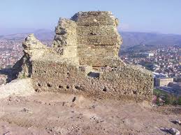
Štip is the urban centre of the eastern part of the Republic of Macedonia with rich and impressive history. The Byzantines called it , and the Ottoman Turks, Istib. Astibos is the Antique name of the river Bregalnica that flows through the city and, through history, served as a natural barrier to its enemies and conquerors.
The city spreads across numerous hills; houses, churches and other public buildings and towers were built below and on them. However, the entire city cannot be seen from any of them, which is one of its specific features. Isarot is the most imposing and, at the same time, the most impressive among these hills, whose cliffs rise over the river Bregalnica. The surviving remains of the city’s citadel stand on the highest flattened point of the hill, where the city administration and its elite had their residences.
The walls which surround this space are massive and strong, and the legend has it that the old master builders mixed thousands of eggs with the mortar while building the ramparts. Such is the main tower, too, which was also the residence of the city mayor and was the most difficult to seize. Today, in addition, one can also see the water cisterns; there must have also been buildings for food storage, a kitchen, a dining hall and other chambers for the proper functioning of a decent and, at times, opulent life. Under these ramparts, especially on the east and south sides, the second and larger city wall with towers also survives, which customarily provided the lodging quarters for the city and state officials and the military.
The area at the foot of Isarot was also inhabited, and in the Middle Ages it was known as Varoš.
In 1018, the armies of the Byzantine Empire conquered the city that had previously been ruled by Tsar Samuil. The people of the city met the Byzantine emperor with song and hymns. The ruins which date from this period are heavily damaged and are still under the ground. During the 12th and the 13th centuries, Štip was a Byzantine city of crucial importance, and its rise was based on trade and the crafts. Until the late 14th century, the mediaeval city stretched around the east and south sides of the fortification and the small river Otinja.
Around 1300, the city was under the Serbian Nemanjić dynasty. Despot Jovan Oliver, Hrelja, voyvoda Dimitar Dragaš, the feudal lord Ivanko and others are recorded as the regional feudal rulers, who commissioned the building of several churches. Among them, the following churches survive: the Church of the Holy Archangels situated east of Isarot; the church dedicated to St. John Glavato on the southwest slope of Isarot; the Church of the Ascension (Church of the Holy Saviour) that stands on the hill opposite of Isarot and the river Otinja. At that time, there were also churches dedicated to St. Blachern, the Holy Archangel, St. Elijah and others.
A number of facts and details from the city’s life and its inhabitants originate from the Ottoman period which began in Štip in 1395. Previously, the Ottomans had captured the city, having discovered the secret corridor that descended from the acropolis, down the steepest hillside, and led to the river Bregalnica. It was on this side of the fortress and the city that the Ottomans established the quarter for the guardians of the gorge called Novo Selo. The guardians defended and controlled access to the city through the gorge and the bridge on the Bregalnica. The prosperity of Štip during the Ottoman period is visible in several structures, such as the Husa Medin Pasha’s Mosque, also known as St. Elijah, as well as the Covered Bazaar, an architectural masterpiece situated at the heart of the city. In the 17th century, the travel writer Evliya Çelebi noted in his writings that the beauty of the women of Štip is known worldwide. Three ethnical, cultural and religious components comprised the foundations and brought about the prosperity of Štip. These were its Macedonian, Turkish and Jewish citizens.
Kostoperska Karpa
Kostoperska Karpa (Žegligovski Kamen)
Kiril Trajkovski
This site overlooks the present-day village of Mlado Nagoričino, 10 km northeast of Kumanovo and the international road which runs towards the east and the city of Kjustendil, Bulgaria. It also represents the remains of the Antique main road Scupi (Skopje) – Serdica (Sofia).
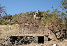
The natural volcanic phenomenon known as Žegligovski Kamen is the crucial point of the Žegligovo region, an area well known in history. It is a basalt cone-shaped rock whose top was used by the population as an ossuary, which inspired the local inhabitants to term it Kostoperska Karpa. In a 500 m diameter area surrounding the rock, remnants of a settlement from the Bronze Age have been discovered, which has been partly destroyed with the building of a modern road.
The west slope of the rock was the burial site of the population during the Roman period, i.e., in the 3rd and 4th centuries AD. The graves contained personal belongings of the deceased which they used in everyday life.
The highest isohypse of the rock was surrounded by a defensive wall that, as a whole, had the features of a small acropolis. Inside it, archaeologists have discovered an Early Christian church from the 6th century in whose vicinity the population buried people belonging to a certain rank.
The underground structures discovered on the south side of the rock remain the most extraordinary and unique structures of their kind on the Balkan Peninsula. They are completely built inside the hill whose geological structure consists of tuff. They have niches and benches used for sitting or sleeping; there is also a staircase which led deeper into the chambers built at a lower level. The air circulated through vertical ventiducts which also served for gathering rainwater in the interior of this extraordinary system of construction and exceptional function. The small entrance led to the interior of the chambers and was closed with a massive stone slab that resembles a millstone. In the space that has only partially been explored, the archaeologists have discovered pottery and glass shards, as well as bones of animals that the inhabitants had cooked. Such a reduced or hermetic model of living is the result of the turbulent times in the Byzantine Empire that was exposed to barbarian incursions; hence, the population sought shelter in the so –called “dead cities.” Almost identical structures, built at the same time, have been discovered in the provinces of Asia Minor, in Cappadocia, in Syria, as well as on the Crimean Peninsula. The structures under the rock of Žegligovski Kamen are, at present, unique on the Balkan Peninsula.
References
B. Georgievski, “Podzemniot objekt kaj Kumanovo”, Lihnid 7, Ohrid 1989, 95-100.
Morodvis
Morodvis is the name of one of the most beautiful villages in eastern Macedonia. It lies at the foot of Mt. Plačkovica whose slopes glisten in more than twenty hues of green.
Random finds from the Early Roman period (1st to 4th centuries AD) have been discovered both in the village and in its vicinity. They speak of the existence of a small settlement with an urban and luxurious style of life. The name of the small town of Harmonia is recorded in Early Byzantine documents (5th to 7th centuries AD); it was situated in this part of Macedonia and it is very likely that it lies under the houses and yards of the present-day village of Morodvis.
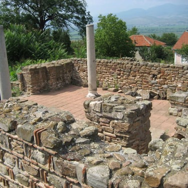
It has been established with certainty that a Christian community lived here in the 5th century, while the faithful gathered in the temple discovered in the centre of the village known as Crkvište. This is a single-nave building with a baptisterium on the north side and a monumental underground vaulted tomb with Early Christian insignia. Around 855, the area of the river Bregalnica and the village of Morodvis was the site of the political and Christian mission of the Byzantine erudite and philologist Constantine the Philosopher (St. Cyril of Salonica) and it was precisely in this area that he composed the Slavonic alphabet.
During the reign of the Bulgarian Prince Boris Michael and his son Simeon, in the second half of the 9th century, Macedonia was annexed to the Bulgarian state; this marked the beginning of the building of numerous churches and monasteries. One such church was discovered above the Early Christian church in Morodvis whose foundations indicate that it was a domed cross-shaped structure. In the underground tomb, on its south side, relics of five saints with miraculous powers have been found. These are probably the remains of the five Early Christian martyrs from the city of Tiberiopolis (present-day Strumica). Their relics were transferred to Morodvis because of their miraculous properties, in order to attract pilgrims.
During emperors Samuil (976-1014) and Basil II (976-10-25), the town was known as Morobisdos, i.e., Morvisd. Morovisd was the most important administrative and political centre of present-day eastern Macedonia and an episcopal see. A cathedral church dating from the 11th century, one of the most harmoniously built three-nave churches of the Middle Byzantine period in Macedonia, has been discovered on the site of Crkvište. The marble mobiliary and the surviving fragments of the fresco painting that have been discovered are indicative of the highly ceremonial character of this building and its meaning which, with certain reconstructions, survived to the end of the 13th century. In mid-12th century, the great Arabic geographer, cartographer and botanist, Al Idrisi, recorded this town on the maps as Murumizdus or Formendos. He also wrote that it is “densely populated and stands on a hill. It has many vineyards and ploughed fields as far as the eye can see.” This is true of the village of Morodvis even today.
Various objects that the population used in their everyday lives, and especially jewellery, have also been found in their graves. Roman, Byzantine, ‘Latin’ and Bulagrian coins have been discovered in this area, as well silver coins from Venice, Genoa and Ragusa (Dubrovnik).
In 1198, the Byzantine Emperor Alexius III issued a Privilegium to the Dodge of Venice Enrico Dandolo, which granted the Venetian merchants free trade with the province of Morovisd.
During the 13th century, in times of war, this region of Macedonia and the city of Morovisd changed masters seven times – Byzantium, the Latins, Bulgaria and eventually Serbia. The agony of the town is also reflected in the ruins that have been excavated. On the site of the demolished Episcopal church, towards the end of the 13th century a smaller and less lavish cross-shaped church with a dome was built.
In the second half of the 14th century, Morovisd was part of the principality of the Dragaš family, until 1395, when the Ottomans became its absolute masters. As local feudal lords and Muslims, they prayed in the mosque by the “old water fountain” in the village then known as the village of Morozda.
References
Ü.IvanovÝ, ”SÎverna Makedoni®, EpiskopiitÎ brÎgalni{ka i velbu`dska,” Sofi® 1906, 72-100.
K. Trajkovski, ”Srednovekovniot grad Morodvis vo Makedonija”, Trud ÃI V MUSA Kiev 1985, Moskva 1987, 89-93.
K. Trajkovski, ”Kultot na mo{tite vo Bregalni~kata dolina”, Folia Archaeologica Balkanica, in Honorem V.Bitrakova Grozdanova, Skopje 2006, 439-445.
Tiveriopolis
Churches of the Fifteen Holy Martyrs of Tiberiopolis in Strumica
Kiril Trajkovski
The churches and graves of the Fifteen Holy Martyrs of Tiberiopolis are situated in the centre of the city of Strumica. Tiberiopolis is the name of the city one day’s walk north of Thessalonica, which was known in Antiquity as Astraion or Star City.
The memory of the people of Strumica and their devoutness and veneration of saintliness have persisted for 1,600 years; thus, in 1972, well-meaning amateurs discovered one of a number of Early Christian tombs of the Fifteen Holy Martyrs of Tiberiopolis. Who were these martyrs? During the Roman Emperor Julian the Apostate (Renegade) who ruled between 361 and 363, Christians suffered terribly or were persecuted. Thus, four men from the city of Nicaea in Asia Minor secretly escaped, reached Thessalonica and proceeded from there to Tiberiopolis (Strumica) to preach Christianity. Timothy, the first of them, became bishop, Comassius and Eusebius became monks, and Theodore was one of the blessed fathers of the Council of Nicaea who was also honoured with the rank of bishop.
Soon, while they were preaching the holy Gospel to the virtue-loving population of Strumica and the region, they were joined by eleven men who became presbyters (Peter, John, Sergius, Theodore, Nicephorus), deacons (Basil, Thomas) and monks (Hierotheus, Daniel, Chariton). The fifteenth man whose name was Socrates was a soldier of great riches and glory, which he renounced and joined the holy fathers. The vigorous and productive Christian life of the fifteen fathers transformed the entire population of Strumica into followers of Christ and sowed the seeds of monastic life in Macedonia. However, the cruelty and ferociousness of the authorities were so great and inconceivable that they arrested them and sentenced them to death by quartering their bodies into pieces. They all perished on 28 November and parts of their bodies were desecrated, scattered around and left to the dogs, beasts and birds. It was only after their executioners left that the Christians gathered their remains with great honour and laid them to rest in Tiberiopolis.
The three-nave basilica with marble decorations and mosaic floors that has been discovered, as well as most of the vaulted early Christian tombs inside it decorated with crosses bear witness to this event that took place in the 4th century. In the 7th century, the city was devastated by the Avars, and the holy temples were levelled to the ground; thus, the tombs were buried under them, as it was recorded in the mediaeval manuscript of Teophylactus, Archbishop of Ohrid, in the 12th century. In the 9th century, the Bulgarian Prince Boris Michael built and restored many churches, especially in the regions of Strumica and Bregalnica. One of these monuments built in the spirit of the Macedonian renaissance was built above the tombs which cherished the memory of the Holy Martyrs of Tiberiopolis. In the central part of this church a crypt has been discovered in whose interior the fresco paintings of the figures of the fifteen martyrs can still be seen today.
In the 12th century the church was remodelled, while the three-part structure was preserved. The faithful added a parekklesion on its southeast side.
The veneration of the Fifteen Holy Martyrs, as well as the wish of the faithful to be near them, can be followed throughout the mediaeval period, when it became the burial site of the people of Strumica. The cult of the Fifteen Holy Martyrs of Tiberiopolis survives to this day, and to the Macedonian Christians, they epitomize ultimate saintliness.
References:
Teofilakt Ohridski, M√~eni~estvoto na 15-te tiveripolski m√~enici, IBI, Grcki izvori, IX, ~. II, 42-79, SofiÔ 1994.
D. Koco & P. Miqkovic, ”Rezultatite od arheolo{kite iskopuvawa vo 1973 god. vo crkvata “Sv. 15 tiveriopolski ma~enici” Strumica, Zb.AM, Skopje 1978, 93-104.
C.Grozdanov, Portreti na svetitelite od Makedonija od IX-XVII vek, Skopje 1983,127-138.